___Argo Mixed Layers
Argo logo SIO logo

Introduction:

We have compiled a mixed layer climatology and database (described in Holte et al. 2017) using Argo profiles and a hybrid method (Holte and Talley 2009) for finding the mixed layer depth (MLD). The climatology incorporates nearly 2,620,000 Argo profiles (April 2022). The new hybrid algorithm models the general shape of each profile, searches for physical features in the profile, and calculates threshold and gradient MLDs to assemble a suite of possible MLD values. It then analyzes the patterns in the suite to select a final MLD estimate. Results are also presented for MLDs calculated using de Boyer Montégut et al.'s (2004) threshold values.

Two forms of Argo MLDs are provided (updated April 2022):
  • Mixed layer depths and properties (density, temperature, and salinity) for every profile in the Argo data set.

  • Climatology of monthly mixed layer depths (mean, median, maximum, and standard deviation) and properties (mean potential density, conservative temperature, and absolute salinity) averaged into 1 degree bins. These fields are averages over the entire Argo record, producing a representative annual cycle of monthly mixed layer properties.
These files contain the mixed layer depths and properties as calculated by the density algorithm and the density threshold. Each also includes the mixed layer depths calculated by the temperature algorithm and the temperature threshold. A MATLAB version of the algorithm is also available here. Older versions of the database are available below.
Data:
The output includes nearly 2,450,000 delayed-mode and real-time Argo profiles, collected between January 2000 and March 2021. The profiles were screened with some simple quality controls.
Mixed layer depths and properties for all Argo profiles:

The following fields are calculated for each individual Argo profile:

  • profile date
  • profile latitude
  • profile longitude
  • float number (WMO number)
  • profile number
  • status (delayed mode corresponds to 1)

  • mixed layer depth from density algorithm
  • mixed layer average temperature using density algorithm MLD
  • mixed layer average salinity using density algorithm MLD
  • mixed layer average potential density using density algorithm MLD

  • mixed layer depth from density threshold method
  • mixed layer average temperature using density threshold MLD
  • mixed layer average salinity using density threshold MLD
  • mixed layer average potential density using density threshold MLD

  • mixed layer depth from temperature algorithm
  • mixed layer depth from temperature threshold method
Monthly mixed layer climatology:

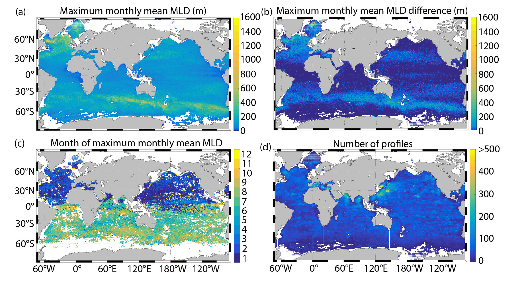
The climatology is determined by grouping the profiles into 1 degree bins and then calculating the mean, median, maximum, and standard deviation of the MLDs for each month, as well as the monthly mean mixed layer temperatures, salinities, and potential densities. These variables are calculated separately using the density algorithm and the density threshold. The maximum MLD is calculated as the mean of the three deepest MLDs. The monthly mean MLDs calculated by the temperature algorithm and the temperature threshold are also included. The climatology contains the following monthly fields averaged into 1 degree bins:

  • density algorithm mean MLD
  • density algorithm median MLD
  • density algorithm maximum MLD
  • density algorithm MLD standard deviation

  • density threshold mean MLD
  • density threshold median MLD
  • density threshold maximum MLD
  • density threshold MLD standard deviation

  • mean mixed layer temperature, salinity, and potential density calculated with the density algorithm mean MLD
  • mean mixed layer temperature, salinity, and potential density calculated with the density threhsold mean MLD

  • temperature algorithm mean MLD
  • temperature threshold mean MLD
Old versions of the database
  • Mixed layer depths and properties for every profile in the Argo data set:

  • Climatology of monthly mixed layer depths:
  • Acknowledgements:
    If you use this data, please cite it as:
    Holte, J., L. D. Talley, J. Gilson, and D. Roemmich (2017), An Argo mixed layer climatology and database, Geophys. Res. Lett., 44, 5618–5626, doi:10.1002/2017GL073426.

    The Argo data used to create this climatology were collected and made freely available by the International Argo Program and the national programs that contribute to it. (http://www.argo.ucsd.edu, http://argo.jcommops.org). The Argo Program is part of the Global Ocean Observing System. doi.org/10.17882/42182#56126
    Links:
  • Holte et al. 2017 (GRL paper describing the climatology)
  • Holte and Talley 2009 (JTECH paper on the algorithm)
  • Argo data browser
  • Ocean Sciences presentation on the Argo MLD climatology
  • Algorithm MATLAB code and demo
  • de Boyer Montégut et al. (2004) MLD climatology
  • Send Jamie Holte an email if you need more information or have questions or comments.

    Funding from the National Science Foundation (OCE-0327544 to L. Talley and T. Chereskin), and U.S. Argo through NOAA (Grant NA17RJ1231 to SIO-JIMO, D. Roemmich) © 2020 Scripps Institution of Oceanography, UC San Diego. All Rights Reserved.